
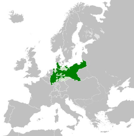
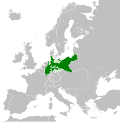
ფაილი:Kingdom of Prussia 1870.svg

ათე SVG ფაილიშ PNG გიწოთოლორაფაშ ზჷმა რე: 450 × 456 პიქსელი. შხვა გოფართაფა: 237 × 240 პიქსელი | 474 × 480 პიქსელი | 758 × 768 პიქსელი | 1,011 × 1,024 პიქსელი | 2,021 × 2,048 პიქსელი.
ორიგინალი ფაილი (SVG ფაილი, ნომინალურო 450 × 456 პიქსელი, ფაილიშ ზჷმა: 705 კბ)
რეზიუმე
This W3C-unspecified vector image was created with Inkscape .


.svg)
.svg)
.svg)
.svg)
.svg)


.svg)
.svg)
.svg)


.png)
.png)


.svg)


.svg)

.svg)


.svg)
.svg)
.svg)
.svg)


.svg)
.png)


.svg)


.svg)
.svg)


.svg)


.svg)


.svg)
.svg)
.svg)
.svg)
.svg)
.svg)
.svg)
_cropped.svg)
.svg)
.svg)
.svg)
.svg)
.svg)
.svg)
.svg)
.svg)
.svg)
.svg)
.svg)
.svg)
.svg)
.svg)
.svg)
.svg)
.svg)
.svg)
.svg)
.svg)
.svg)
.svg)
.svg)
.svg)
.svg)
.svg)
.svg)
.svg)
.svg)
.svg)
.svg)
.svg)
.svg)
.svg)
.svg)
.svg)
.svg)
.svg)
.svg)
.svg)
.svg)
.svg)
.svg)
.svg)
.svg)
ლიცენზირაფა
This file is licensed under the Creative Commons Attribution-Share Alike 4.0 International license.
- თქვა დუდიშულო შეილებჷნა:
- ნახანდიშ გობჟინაფა – ნახანდიშ კოპირაფა, გობჟინაფა დო გჷნოჩამა.
- დორსხილეფიშ აკოქიმინუა – ნახანდიშ გიშათინუა
- გეჸვენჯი პიჯალეფით:
- ავტორიშ მეწურაფა – თქვა წყუშ აკმაქიმინალი მეუწურუათ ოკო თი შარათ, მუჭოთ დარინუ ავტორქ ვარდა საავტორო ნებეფიშ მაღვენჯიქ. მარა ვართ თეშ, ითამ წყუშ ავტორქ ალობა მერჩეს თქვა ვარდა ალობა მეჩჷ თქვანიშით აკოქიმინელჷ ნოწარმუს.
- კჷნ მანგი პიჯალეფით გობჟინაფა – დო თქვა ქოთირანთ, ვარ-და გჷთმაჭყანთ ახალ ნახანდის თე ნახანდიშ გჷმორინაფათ-და, თქვა გიღჷნა ნება თინა გაბჟინუათ კჷნ თი ვარ-და ომანგე ლიცენზიათ, ნამუშჷთ იბჟინუაფჷ წყუ.
ფაილიშ ისტორია
ქიგუნჭირით რიცხვის/ბორჯის თიშო, ნამჷ-და ქოძირათ ფაილი თი რედაქციათ, ნამუ რედაქციას თი რიცხვის/ბორჯის რდუნ.
| რიცხუ/ბორჯი | ჭკუდი | გონზჷმილაფეფი | მახვარებუ | კომენტარი | |
|---|---|---|---|---|---|
| მიმალი | 06:54, 1 მანგი 2016 | | 450 × 456 (705 კბ) | Alphathon | Various corrections to the states of the North German Confederation |
| 09:22, 31 მესი 2016 |  | 450 × 456 (662 კბ) | Alphathon | Minor corrections (Tarasp and post-1818 German Confederation border change) | |
| 06:40, 31 მესი 2016 |  | 450 × 456 (662 კბ) | Alphathon | == {{int:filedesc}} == {{Inkscape}} {{Information |Description={{en|A map of the en:Kingdom of Prussia within the North German Confederation and within Europe circa 1870 CE.}} |Source= {{Derived from|Blank_map_of_Europe.svg|display=50}} |Da... |
ფაილიშ გჷმორინაფა
გეჸვენჯი ხასჷლა გჷმირინუანს თე ფაილს:
ფაილიშ გლობალური გჷმორინაფა
თე ფაილი გჷმირინუაფუ გეჸვენჯი ვიკეფს:
- af.wiktionary.org-ს გჷმორინაფა
- ar.wikipedia.org-ს გჷმორინაფა
- bn.wikipedia.org-ს გჷმორინაფა
- ckb.wikipedia.org-ს გჷმორინაფა
- en.wikipedia.org-ს გჷმორინაფა
- eo.wiktionary.org-ს გჷმორინაფა
- es.wikipedia.org-ს გჷმორინაფა
- es.wiktionary.org-ს გჷმორინაფა
- eu.wikipedia.org-ს გჷმორინაფა
- fa.wikipedia.org-ს გჷმორინაფა
- fi.wikipedia.org-ს გჷმორინაფა
- he.wikipedia.org-ს გჷმორინაფა
- hu.wikipedia.org-ს გჷმორინაფა
- is.wikipedia.org-ს გჷმორინაფა
- it.wikipedia.org-ს გჷმორინაფა
- li.wiktionary.org-ს გჷმორინაფა
- lld.wikipedia.org-ს გჷმორინაფა
- lt.wikipedia.org-ს გჷმორინაფა
- mn.wikipedia.org-ს გჷმორინაფა
- pl.wikipedia.org-ს გჷმორინაფა
- rue.wikipedia.org-ს გჷმორინაფა
- ru.wikipedia.org-ს გჷმორინაფა
- ru.wiktionary.org-ს გჷმორინაფა
- sk.wikipedia.org-ს გჷმორინაფა
- szl.wikipedia.org-ს გჷმორინაფა
- tr.wikipedia.org-ს გჷმორინაფა
- uk.wikipedia.org-ს გჷმორინაფა
- uz.wikipedia.org-ს გჷმორინაფა
- zh.wikipedia.org-ს გჷმორინაფა