
ფაილი:Topography of africa.jpg

ზჷმა გიწოთოლორაფაშ ბორჯის: 548 × 599 პიქსელი. შხვა გოფართაფა: 219 × 240 პიქსელი | 439 × 480 პიქსელი | 702 × 768 პიქსელი | 936 × 1,024 პიქსელი | 1,463 × 1,600 პიქსელი.
ორიგინალი ფაილი (1,463 × 1,600 პიქსელი, ფაილიშ ზჷმა: 475 კბ, MIME ტიპი: image/jpeg)
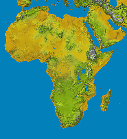
Topography of Africa
image description here:
- PIA04965: SRTM Data Release for Africa, Colored Height
- Elevation data at the highest possible resolution from NASA's SRTM mission in February 2000 are being released for the first time for most of the African continent. This color shaded relief image shows the extent of SRTM digital elevation data for Africa.
- This color shaded relief image shows the extent of digital elevation data for Africa recently released by the Shuttle Radar Topography Mission (SRTM). This release includes data for all of the continent, plus the island of Madagascar and the Arabian Peninsula. SRTM flew on board the Space Shuttle Endeavour in February 2000 and used an interferometric radar system to map the topography of Earth's landmass between latitudes 56 degrees south and 60 degrees north.
larger version here Image credit: NASA/JPL-Caltech
| This file is in the public domain in the United States because it was solely created by NASA. NASA copyright policy states that "NASA material is not protected by copyright unless noted". (See Template:PD-USGov, NASA copyright policy page or JPL Image Use Policy.) | ||
 |
Warnings:
|
ფაილიშ ისტორია
ქიგუნჭირით რიცხვის/ბორჯის თიშო, ნამჷ-და ქოძირათ ფაილი თი რედაქციათ, ნამუ რედაქციას თი რიცხვის/ბორჯის რდუნ.
| რიცხუ/ბორჯი | ჭკუდი | გონზჷმილაფეფი | მახვარებუ | კომენტარი | |
|---|---|---|---|---|---|
| მიმალი | 17:01, 27 ღურთუთა 2006 | | 1,463 × 1,600 (475 კბ) | Perconte~commonswiki | |
| 14:34, 25 ეკენია 2005 |  | 552 × 604 (48 კბ) | ChongDae | This image was copied from wikipedia:en. The original description was: Topography of Africa image description [http://photojournal.jpl.nasa.gov/catalog/PIA04965 here] larger version [http://photojournal.jpl.nasa.gov/jpeg/PIA04965.jpg here] Image credi |
ფაილიშ გჷმორინაფა
გეჸვენჯი ხასჷლა გჷმირინუანს თე ფაილს:
ფაილიშ გლობალური გჷმორინაფა
თე ფაილი გჷმირინუაფუ გეჸვენჯი ვიკეფს:
- ar.wikipedia.org-ს გჷმორინაფა
- cs.wikipedia.org-ს გჷმორინაფა
- cy.wikipedia.org-ს გჷმორინაფა
- de.wikipedia.org-ს გჷმორინაფა
- eml.wikipedia.org-ს გჷმორინაფა
- eo.wikipedia.org-ს გჷმორინაფა
- es.wikipedia.org-ს გჷმორინაფა
- et.wikipedia.org-ს გჷმორინაფა
- eu.wikipedia.org-ს გჷმორინაფა
- fa.wikipedia.org-ს გჷმორინაფა
- hy.wikipedia.org-ს გჷმორინაფა
- ie.wikipedia.org-ს გჷმორინაფა
- incubator.wikimedia.org-ს გჷმორინაფა
- it.wikipedia.org-ს გჷმორინაფა
- it.wikibooks.org-ს გჷმორინაფა
- it.wikiversity.org-ს გჷმორინაფა
- ja.wikipedia.org-ს გჷმორინაფა
- kab.wikipedia.org-ს გჷმორინაფა
- ka.wikipedia.org-ს გჷმორინაფა
- kn.wikipedia.org-ს გჷმორინაფა
- ko.wikipedia.org-ს გჷმორინაფა
- lld.wikipedia.org-ს გჷმორინაფა
- lmo.wikipedia.org-ს გჷმორინაფა
- ml.wikipedia.org-ს გჷმორინაფა
- nl.wikipedia.org-ს გჷმორინაფა
- nrm.wikipedia.org-ს გჷმორინაფა
- pl.wikipedia.org-ს გჷმორინაფა
- pms.wikipedia.org-ს გჷმორინაფა
ქოძირით, თე ფაილიშ გლობალური გიმორინაფა.