
ფაილი:Mingachevir Reservoir, Azerbaijan.JPG

ზჷმა გიწოთოლორაფაშ ბორჯის: 398 × 599 პიქსელი. შხვა გოფართაფა: 159 × 240 პიქსელი | 319 × 480 პიქსელი | 510 × 768 პიქსელი | 680 × 1,024 პიქსელი | 1,361 × 2,048 პიქსელი | 2,829 × 4,256 პიქსელი.
ორიგინალი ფაილი (2,829 × 4,256 პიქსელი, ფაილიშ ზჷმა: 2.08 მბ, MIME ტიპი: image/jpeg)
რეზიუმე
| ეჭარუა |
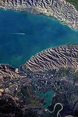
English: This detailed astronaut photograph highlights the southern Mingachevir Reservoir in north-central Azerbaijan. Folded layers of relatively young (less than 5. 3 million years old) sedimentary rock, explosive volcanic products (ash and tuff), and unconsolidated sediments form the grey hills along the northern and southern shorelines of the reservoir (image centre and right). Afternoon sun highlights distinctive parallel patterns in the hills that are the result of water and wind erosion of different rock layers exposed at the surface. The nearby city of Mingachevir (left) is split by the Kur River after it passes through the dam and hydroelectric power station complex at image top centre. The reservoir held approximately 15 billion cubic meters of water at the time this image was taken, with a total engineered capacity of 16 billion cubic meters. The width of the reservoir illustrated here is approximately 8 kilometres; a jet flying over the reservoir left a contrail midway between the shorelines. |
| თარიღი | |
| წყუ | NASA Earth Observatory |
| ავტორი | ISS Expedition 23 crew |
| კამერის მდებარეობა | | იხილეთ ეს და სხვა ახლომდებარე სურათები საიტ(ებ)ზე OpenStreetMap |
|---|
This image or video was catalogued by Johnson Space Center of the United States National Aeronautics and Space Administration (NASA) under Photo ID: ISS023-E-35670. This tag does not indicate the copyright status of the attached work. A normal copyright tag is still required. See Commons:Licensing. Other languages:
|
Image captured with a Nikon D3S digital camera, and is provided by the ISS Crew Earth Observations experiment and Image Science & Analysis Laboratory, Johnson Space Center.
ლიცენზირაფა
| This file is in the public domain in the United States because it was solely created by NASA. NASA copyright policy states that "NASA material is not protected by copyright unless noted". (See Template:PD-USGov, NASA copyright policy page or JPL Image Use Policy.) | ||
 |
Warnings:
|
| Annotations | This image is annotated: View the annotations at Commons |
ფაილიშ ისტორია
ქიგუნჭირით რიცხვის/ბორჯის თიშო, ნამჷ-და ქოძირათ ფაილი თი რედაქციათ, ნამუ რედაქციას თი რიცხვის/ბორჯის რდუნ.
| რიცხუ/ბორჯი | ჭკუდი | გონზჷმილაფეფი | მახვარებუ | კომენტარი | |
|---|---|---|---|---|---|
| მიმალი | 14:00, 18 მანგი 2018 | | 2,829 × 4,256 (2.08 მბ) | SteinsplitterBot | Bot: Image rotated by 270° |
| 20:54, 7 მანგი 2010 |  | 4,256 × 2,829 (2.09 მბ) | Originalwana | {{Information |Description={{en|1=This detailed astronaut photograph highlights the southern Mingachevir Reservoir in north-central Azerbaijan. Folded layers of relatively young (less than 5. 3 million years old) sedimentary rock, explosive volcanic p |
ფაილიშ გჷმორინაფა
გეჸვენჯი ხასჷლა გჷმირინუანს თე ფაილს:
ფაილიშ გლობალური გჷმორინაფა
თე ფაილი გჷმირინუაფუ გეჸვენჯი ვიკეფს:
- arz.wikipedia.org-ს გჷმორინაფა
- azb.wikipedia.org-ს გჷმორინაფა
- az.wikipedia.org-ს გჷმორინაფა
- az.wiktionary.org-ს გჷმორინაფა
- be.wikipedia.org-ს გჷმორინაფა
- ca.wikipedia.org-ს გჷმორინაფა
- ceb.wikipedia.org-ს გჷმორინაფა
- cs.wikipedia.org-ს გჷმორინაფა
- de.wikipedia.org-ს გჷმორინაფა
- en.wikipedia.org-ს გჷმორინაფა
- eo.wikipedia.org-ს გჷმორინაფა
- es.wikipedia.org-ს გჷმორინაფა
- fa.wikipedia.org-ს გჷმორინაფა
- fi.wikipedia.org-ს გჷმორინაფა
- fr.wikipedia.org-ს გჷმორინაფა
- fy.wikipedia.org-ს გჷმორინაფა
- he.wikipedia.org-ს გჷმორინაფა
- hr.wikipedia.org-ს გჷმორინაფა
- hu.wikipedia.org-ს გჷმორინაფა
- hy.wikipedia.org-ს გჷმორინაფა
- id.wikipedia.org-ს გჷმორინაფა
- ilo.wikipedia.org-ს გჷმორინაფა
- it.wikipedia.org-ს გჷმორინაფა
ქოძირით, თე ფაილიშ გლობალური გიმორინაფა.