
ფაილი:CQA Four Mile Bridge.jpg
ზჷმა გიწოთოლორაფაშ ბორჯის: 753 × 600 პიქსელი. შხვა გოფართაფა: 301 × 240 პიქსელი | 603 × 480 პიქსელი | 964 × 768 პიქსელი | 1,280 × 1,020 პიქსელი | 2,560 × 2,039 პიქსელი | 4,624 × 3,683 პიქსელი.
ორიგინალი ფაილი (4,624 × 3,683 პიქსელი, ფაილიშ ზჷმა: 1.88 მბ, MIME ტიპი: image/jpeg)
|
This is an image of a place or building that is listed on the National Register of Historic Places in the United States of America. Its reference number is 85000423. |
| კამერის მდებარეობა | | იხილეთ ეს და სხვა ახლომდებარე სურათები საიტ(ებ)ზე OpenStreetMap |
|---|
| ეჭარუა |
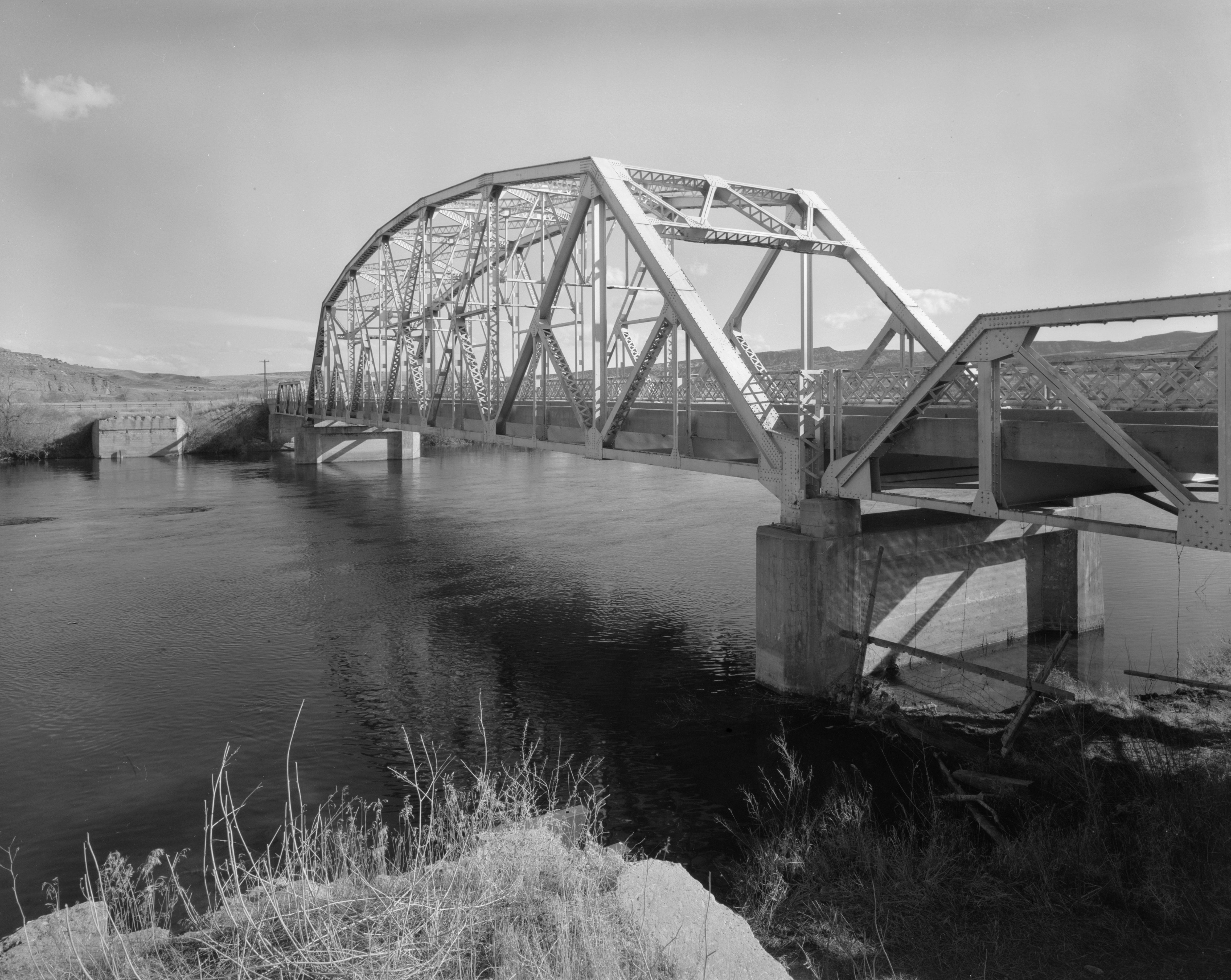
English: Eastern side of the CQA Four Mile Bridge, which carries WYO 173 over the Bighorn River near Thermopolis in Hot Springs County, Wyoming, United States. Built in 1927, this Pennsylvania through truss bridge is listed on the National Register of Historic Places. |
||||
| თარიღი | |||||
| წყუ |
Library of Congress, Prints and Photograph Division HAER: WYO,9-THERM.V,2-1
|
||||
| ავტორი | Clayton B. Fraser | ||||
| ალობა: (ფაილიშ კინე გიმორინაფა) |
|

ფაილიშ ისტორია
ქიგუნჭირით რიცხვის/ბორჯის თიშო, ნამჷ-და ქოძირათ ფაილი თი რედაქციათ, ნამუ რედაქციას თი რიცხვის/ბორჯის რდუნ.
| რიცხუ/ბორჯი | ჭკუდი | გონზჷმილაფეფი | მახვარებუ | კომენტარი | |
|---|---|---|---|---|---|
| მიმალი | 20:14, 27 პირელი 2009 | | 4,624 × 3,683 (1.88 მბ) | Martin H. | high res; cropped |
| 19:18, 25 პირელი 2009 |  | 1,024 × 820 (170 კბ) | Nyttend | {{Location|43|36|13|N|108|11|48|W}} {{Information |Description={{en|Eastern side of the {{w|CQA Four Mile Bridge}}, which carries {{w|Wyoming Highway 173|WYO 173}} over the {{w|Bighorn River}} near {{w|Thermopolis, Wyoming|Thermopolis}} in {{w|Hot Springs |
ფაილიშ გჷმორინაფა
გეჸვენჯი ხასჷლა გჷმირინუანს თე ფაილს:
ფაილიშ გლობალური გჷმორინაფა
თე ფაილი გჷმირინუაფუ გეჸვენჯი ვიკეფს:
- arz.wikipedia.org-ს გჷმორინაფა
- ca.wikipedia.org-ს გჷმორინაფა
- ceb.wikipedia.org-ს გჷმორინაფა
- da.wikipedia.org-ს გჷმორინაფა
- de.wikipedia.org-ს გჷმორინაფა
- en.wikipedia.org-ს გჷმორინაფა
- no.wikipedia.org-ს გჷმორინაფა
- sv.wikipedia.org-ს გჷმორინაფა
- www.wikidata.org-ს გჷმორინაფა