დინორეშა გინულა

ფაილი:Maurya Empire, c.250 BCE 2.png

ხასჷლაშ დინორე შხვა ნინაშა ვა რე ხემიოლი.
ვიკიპედიაშე

ორიგინალი ფაილი (1,200 × 1,121 პიქსელი, ფაილიშ ზჷმა: 2.26 მბ, MIME ტიპი: image/png)

თე ფაილი რე Wikimedia Commons-შე დო შილებე გჷმორნაფილქ იჸუას შხვა პროექტეფს. თეშ ეჭარუა ფაილიშ ეჭარუაშ ხასჷლა თუდო რე მოჩამილი.

რეზიუმე

ეჭარუა
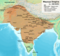
English: Note: This was the traditional map of the Maurya Empire at it's maximum extent, as a solid-mass of Maurya-controlled territory. Historians are now arguing that the Maurya Empire did not include large parts of India, which were controlled by autonomous tribes. For such a map, see File:Maurya Empire, c.250 BCE.png.
Alternative map of Maurya Empire

Boundaries are based on Charles Joppen Historical Atlas of India (1907), see File:India_in_250_B._C.jpg.

Other Sources:

Other sources:

  • Grainger, John D. (1990, 2014). Seleukos Nikator: Constructing a Hellenistic Kingdom. Routledge.
  • Keay, John (2000). India, a History. New York: Harper Collins Publishers.
  • Kulke, H.; Rothermund, D. (2004). A History of India, 4th, Routledge.
  • Puri, Baji Nath (1996). Buddhism in Central Asia. Delhi: Motilal Banarsidass.
  • Raychaudhuri, H. C.; Mukherjee, B. N. (1996). Political History of Ancient India: From the Accession of Parikshit to the Extinction of the Gupta Dynasty. Oxford University Press.
  • Stein, Burton (1998). A History of India (1st ed.), Oxford: Wiley-Blackwell.

Notes:

  • Sri Lanka and the southernmost parts of India (modern Tamil Nadu and Kerala) remained independent, despite the diplomacy and cultural influence of their larger neighbor to the north (Schwartzberg 1992, p. 18; Kulke & Rothermund 2004, p. 68).
  • The account of Strabo indicates that the western-most territory of the empire extended from the southeastern Hindu Kush, through the region of Kandahar, to coastal Baluchistan south of that (Raychaudhuri & Mukherjee 1996, p. 594).
  • The claim that Aria/Herat was one of the provinces (alongside Arachosia, Gedrosia, and Paropamisadae) ceded by Seleucus to Chandragupta Maurya is often repeated, but Aria (modern Herat) "has been wrongly included in the list of ceded satrapies by some scholars [...] on the basis of wrong assessments of the passage of Strabo [...] and a statement by Pliny." (Raychaudhuri & Mukherjee 1996, p. 594). Seleucus "must [...] have held Aria", and furthermore, his "son Antiochos was active there fifteen years later." (Grainger 2014, p. 109).
  • "The region of Aria is definitely known to have been Seleucid under Seleucus I and Antiochus I as it definitely was after Antiochus III's great campaign in the east against the Parthians and Bactrians. [...] There is no evidence whatever that it did not remain Seleucid, like Drangiana, with which it is linked by easy routes." -Susan M. Sherwin-White and Amélie Kuhrt (1993) From Samarkhand to Sardis: A New Approach to the Seleucid Empire, University of California Press, pp.79-80.
  • It is recorded that Drangiana province continued to be in the Seleucids' hands, as per [1].
  • "Desert of Gedrosia [...] was left an unclaimed wilderness." —Kosmin, Paul J. (2014), The Land of the Elephant Kings Space, Territory, and Ideology in the Seleucid Empire, Harvard University Press, p.16
  • Schwartzberg (p. 18) speculates about the Buddhist culture and Kharosthi inscriptions/manuscripts found in Khotan, but these texts from Khotan, Turfan, and Tajikstan have all been shown to be later than the 1st century BCE (Puri, p. 185).
თარიღი
წყუ პირადი ნახანდი
ავტორი Avantiputra7

ლიცენზირაფა

მე, ამ ნამუშევარზე საავტორო უფლებების მფლობელი, ვაქვეყნებ მას შემდეგი ლიცენზიით:
w:en:Creative Commons
ავტორიშ მეწურაფა კჷნ მანგი პიჯალეფით გობჟინაფა
თე ნახანდი იბჟინუაფუ Creative Commons Attribution-Share Alike 3.0 Unported ლიცენზიათ.
თქვა დუდიშულო შეილებჷნა:
  • ნახანდიშ გობჟინაფა – ნახანდიშ კოპირაფა, გობჟინაფა დო გჷნოჩამა.
  • დორსხილეფიშ აკოქიმინუა – ნახანდიშ გიშათინუა
გეჸვენჯი პიჯალეფით:
  • ავტორიშ მეწურაფა – თქვა წყუშ აკმაქიმინალი მეუწურუათ ოკო თი შარათ, მუჭოთ დარინუ ავტორქ ვარდა საავტორო ნებეფიშ მაღვენჯიქ. მარა ვართ თეშ, ითამ წყუშ ავტორქ ალობა მერჩეს თქვა ვარდა ალობა მეჩჷ თქვანიშით აკოქიმინელჷ ნოწარმუს.
  • კჷნ მანგი პიჯალეფით გობჟინაფა – დო თქვა ქოთირანთ, ვარ-და გჷთმაჭყანთ ახალ ნახანდის თე ნახანდიშ გჷმორინაფათ-და, თქვა გიღჷნა ნება თინა გაბჟინუათ კჷნ თი ვარ-და ომანგე ლიცენზიათ, ნამუშჷთ იბჟინუაფჷ წყუ.

მუკნაჭარეფი

ართღოზამი ეჭარუაშ გეძინა, დო მუს წჷმარინუანს თე ფაილინ

ელემეტეფი, ნამუეფთ ეხანტილი რე ათე ფაილს

გჷმოხანტილი ობიექტი

შემქმნელი ქართული

ათე ღანთის უღჷ კანკალე შანულობა ს ელემენტიშ უმუშო

source of file ინგლისური

original creation by uploader ინგლისური

media type ინგლისური

image/png

ფაილიშ ისტორია

ქიგუნჭირით რიცხვის/ბორჯის თიშო, ნამჷ-და ქოძირათ ფაილი თი რედაქციათ, ნამუ რედაქციას თი რიცხვის/ბორჯის რდუნ.

(უახალაში | უჯვეშაში) ქოძირე (უახალაშ 10 | ) (10 | 20 | 50 | 100 | 250 | 500).
რიცხუ/ბორჯიჭკუდიგონზჷმილაფეფიმახვარებუკომენტარი
მიმალი12:27, 27 მანგი 2024ჭკუდი 12:27, 27 მანგი 2024-შო რინელჷ ვერსიაშო1,200 × 1,121 (2.26 მბ)Avantiputra7Reverted to version as of 11:01, 30 April 2024 (UTC) - vandalism
12:52, 19 მანგი 2024ჭკუდი 12:52, 19 მანგი 2024-შო რინელჷ ვერსიაშო1,200 × 1,121 (2.18 მბ)Chakravartin1929Reverted to version as of 07:37, 14 April 2024 (UTC) This version is not even based on joppen's map. It's westernmost lands clearly dont match with that of joppen's map hence reverting to this.
15:01, 30 პირელი 2024ჭკუდი 15:01, 30 პირელი 2024-შო რინელჷ ვერსიაშო1,200 × 1,121 (2.26 მბ)Avantiputra7western borders: see talk page
08:37, 16 პირელი 2024ჭკუდი 08:37, 16 პირელი 2024-შო რინელჷ ვერსიაშო1,200 × 1,121 (2.26 მბ)Avantiputra7Reverted to version as of 11:12, 5 April 2024 (UTC) - vandalism
11:37, 14 პირელი 2024ჭკუდი 11:37, 14 პირელი 2024-შო რინელჷ ვერსიაშო1,200 × 1,121 (2.18 მბ)Layman7676Reverted to version as of 11:12, 4 April 2024 (UTC) The map you are publishing isn't based on wha vincient Arthur really said.
15:12, 5 პირელი 2024ჭკუდი 15:12, 5 პირელი 2024-შო რინელჷ ვერსიაშო1,200 × 1,121 (2.26 მბ)Avantiputra7Reverted to version as of 08:27, 3 April 2024 (UTC) - vandalism
15:12, 4 პირელი 2024ჭკუდი 15:12, 4 პირელი 2024-შო რინელჷ ვერსიაშო1,200 × 1,121 (2.18 მბ)Chakravartin1929Reverted to version as of 05:41, 26 March 2024 (UTC) This is the true map. It depicts The mauryan map accurately.
12:27, 3 პირელი 2024ჭკუდი 12:27, 3 პირელი 2024-შო რინელჷ ვერსიაშო1,200 × 1,121 (2.26 მბ)Avantiputra7Reverted to version as of 11:06, 3 March 2024 (UTC)
09:41, 26 მელახი 2024ჭკუდი 09:41, 26 მელახი 2024-შო რინელჷ ვერსიაშო1,200 × 1,121 (2.18 მბ)Chakravartin1929Reverted to version as of 09:06, 3 March 2024 (UTC)
15:06, 3 მელახი 2024ჭკუდი 15:06, 3 მელახი 2024-შო რინელჷ ვერსიაშო1,200 × 1,121 (2.26 მბ)Avantiputra7Reverted to version as of 11:10, 29 January 2024 (UTC)
(უახალაში | უჯვეშაში) ქოძირე (უახალაშ 10 | ) (10 | 20 | 50 | 100 | 250 | 500).

გეჸვენჯი ხასჷლა გჷმირინუანს თე ფაილს:

ფაილიშ გლობალური გჷმორინაფა

თე ფაილი გჷმირინუაფუ გეჸვენჯი ვიკეფს:

ქოძირით, თე ფაილიშ გლობალური გიმორინაფა.

მეტამუნაჩემეფი