
ფაილი:SouthAfricaOMC.png

ზჷმა გიწოთოლორაფაშ ბორჯის: 542 × 599 პიქსელი. შხვა გოფართაფა: 217 × 240 პიქსელი | 434 × 480 პიქსელი | 695 × 768 პიქსელი | 926 × 1,024 პიქსელი | 1,367 × 1,511 პიქსელი.
ორიგინალი ფაილი (1,367 × 1,511 პიქსელი, ფაილიშ ზჷმა: 128 კბ, MIME ტიპი: image/png)
რეზიუმე
| ეჭარუა |
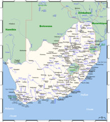
English: A map showing South Africa's cities, main towns, selected villages, rivers, and its highest peak. This map's source is here, with the uploader's modifications, and the GMT homepage says that the tools are released under the GNU General Public License. |
| თარიღი | 20 ქირსეთუთა 2007 (original upload date) |
| წყუ | Transferred from en.wikipedia to Commons by Mario1952 using CommonsHelper. |
| ავტორი |
Kelisi at ინგლისური ვიკიპედია. Later version(s) were uploaded by JMK at en.wikipedia. This map's source is here, with the uploader's modifications, and the GMT homepage says that the tools are released under the GNU General Public License. |
ლიცენზირაფა
Kelisi from en.wikipedia.org, ამ ნამუშევარზე საავტორო უფლებების მფლობელი, ვაქვეყნებ მას შემდეგი ლიცენზიით:
| თე ნახანდი იბჟინუაფუ Creative Commons Attribution-Share Alike 3.0 Unported ლიცენზიათ. Subject to disclaimers. | ||
| ავტორიშ მეწურაფა: Kelisi from en.wikipedia.org | ||
| ||
| ეს ლიცენზირების ნიშანი დაემატა ამ ფაილს, როგორც GFDL ლიცენზიის განახლების ნაწილი. |

|
თქვა შეგილებჷნა გოფაჩათ ვარ-და დოთირუათ დოკუმენტი GNU Free Documentation ლიცენზიაშ 1.2 ვარ-და უმოსი უწმოხიანი ვერსიაშ პიჯალეფიშ მეჯინათ, ნამუთ გჷმობჟინაფილი რე დუდიშული პროგრამული აზარაშ ფონდიშენი, უთირუ გჷნართეფიშ უმუშო, მაართა დო ბოლო ხასჷლეფს მადვალუ ტექსტეფს. ლიცენზიაშ ანგი მილარე გჷნართას ჯოხოთ GNU Free Documentation License. Subject to disclaimers. |
ატვირთვის ჟურნალი
The original description page was here. All following user names refer to en.wikipedia.
- 2007-12-20 10:55 JMK 1367×1511× (109398 bytes) Update under GFDL licence.
- 2007-12-20 10:19 JMK 1367×1511× (109349 bytes) Update under GFDL licence.
- 2007-12-20 09:25 JMK 1367×1511× (109369 bytes) Update under GFDL licence. ~~~~
- 2007-08-21 00:13 Kelisi 1366×1511× (93673 bytes) Updating towns' names.
- 2007-08-19 16:19 Kelisi 1366×1511× (93854 bytes) == Summary == A map showing South Africa's cities, main towns, selected villages, rivers and its highest peak. This map's source is [http://www.aquarius.ifm-geomar.de/ here], with the uploader's modifications, and the [http://gmt.soest.hawaii.edu/ GMT hom
ფაილიშ ისტორია
ქიგუნჭირით რიცხვის/ბორჯის თიშო, ნამჷ-და ქოძირათ ფაილი თი რედაქციათ, ნამუ რედაქციას თი რიცხვის/ბორჯის რდუნ.
| რიცხუ/ბორჯი | ჭკუდი | გონზჷმილაფეფი | მახვარებუ | კომენტარი | |
|---|---|---|---|---|---|
| მიმალი | 09:55, 23 მარაშინათუთა 2023 | | 1,367 × 1,511 (128 კბ) | Kelisi | tweaking |
| 09:47, 4 პირელი 2023 |  | 1,367 × 1,511 (128 კბ) | Kelisi | Two more placename changes | |
| 09:44, 29 მანგი 2022 |  | 1,367 × 1,511 (128 კბ) | Kelisi | Several more names plotted | |
| 21:34, 1 პირელი 2022 |  | 1,367 × 1,511 (128 კბ) | Kelisi | Sizeable town unaccountably overlooked. | |
| 10:00, 5 ფურთუთა 2022 |  | 1,367 × 1,511 (128 კბ) | Kelisi | Several more names plotted | |
| 07:36, 3 ფურთუთა 2022 |  | 1,367 × 1,511 (128 კბ) | Kelisi | Several more names plotted | |
| 11:46, 7 ღურთუთა 2022 |  | 1,367 × 1,511 (128 კბ) | Kelisi | A few placename changes and one misspelling corrected | |
| 22:37, 29 მანგი 2020 |  | 1,367 × 1,511 (128 კბ) | Kelisi | Name changes: Cala→Kala Mafikeng→Mahikeng Nelspruit→Mbombela Piet Retief→eMkhondo | |
| 08:53, 29 მანგი 2020 |  | 1,367 × 1,511 (128 კბ) | Kelisi | Grahamstown→Makhanda | |
| 00:05, 21 მარაშინათუთა 2019 |  | 1,367 × 1,511 (126 კბ) | Kelisi | Swaziland is now called Eswatini. |
ფაილიშ გჷმორინაფა
გეჸვენჯი ხასჷლა გჷმირინუანს თე ფაილს:
ფაილიშ გლობალური გჷმორინაფა
თე ფაილი გჷმირინუაფუ გეჸვენჯი ვიკეფს:
- en.wikinews.org-ს გჷმორინაფა
- ja.wikipedia.org-ს გჷმორინაფა
- pl.wikipedia.org-ს გჷმორინაფა
- pt.wikipedia.org-ს გჷმორინაფა
- ru.wikipedia.org-ს გჷმორინაფა
- simple.wikipedia.org-ს გჷმორინაფა
- sk.wikipedia.org-ს გჷმორინაფა
- sw.wikipedia.org-ს გჷმორინაფა
- uk.wikipedia.org-ს გჷმორინაფა
- www.wikidata.org-ს გჷმორინაფა