
ფაილი:Venezuela Division Politica Territorial.svg

ათე SVG ფაილიშ PNG გიწოთოლორაფაშ ზჷმა რე: 781 × 600 პიქსელი. შხვა გოფართაფა: 313 × 240 პიქსელი | 625 × 480 პიქსელი | 1,000 × 768 პიქსელი | 1,280 × 983 პიქსელი | 2,560 × 1,966 პიქსელი | 2,121 × 1,629 პიქსელი.
ორიგინალი ფაილი (SVG ფაილი, ნომინალურო 2,121 × 1,629 პიქსელი, ფაილიშ ზჷმა: 141 კბ)
| ეჭარუა |
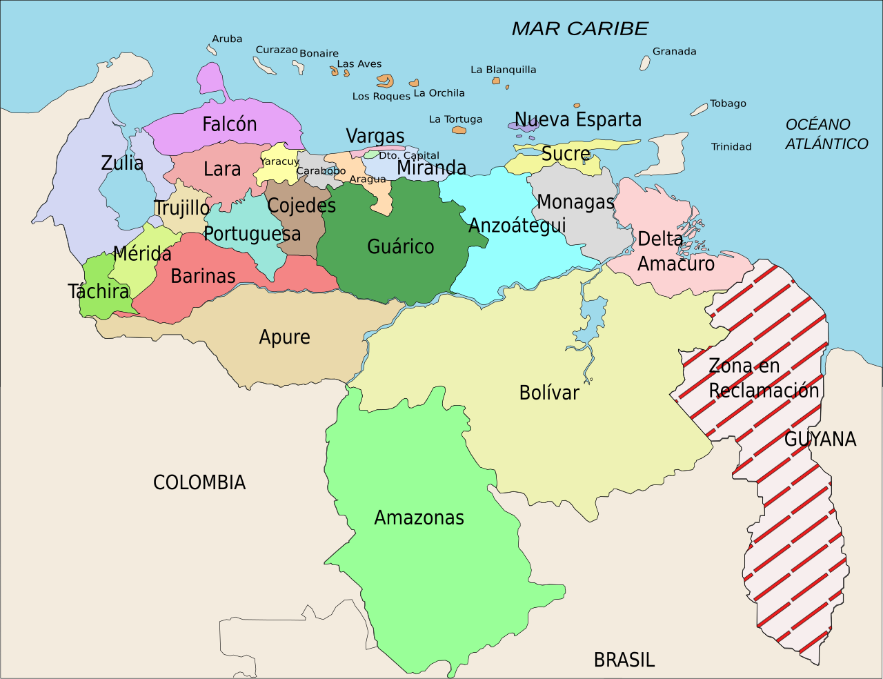
Español: División Político Territorial de Venezuela. Es un mapa acerca de los estados de Venezuela o división político territorial. La zona en reclamación aun no se sabe si pertenece a Guyana o a Venezuela, por eso se suele colocar de esa manera.
English: Political divisions of Venezuela. The Reclamation zone is Guyanan territory claimed by Venezuela. |
| თარიღი | |
| წყუ | self work, Image:Venezuela politica copy.png based |
| ავტორი | Wilfredor |
| ალობა: (ფაილიშ კინე გიმორინაფა) |
Own work, copyleft: Multi-license with GFDL and Creative Commons CC-BY-SA-2.5 and older versions (2.0 and 1.0) |
| სხვა ვერსიები |
Derivative works of this file: Venezuela Division Politica Territorial mk.svg
[]
|


This W3C-unspecified vector image was created with Inkscape .
მე, ამ ნაწარმოებზე საავტორო უფლებების მფლობელი, საკუთარი სურვილით ვაქვეყნებ მას შემდეგი ლიცენზიით:

|
თქვა შეგილებჷნა გოფაჩათ ვარ-და დოთირუათ დოკუმენტი GNU Free Documentation ლიცენზიაშ 1.2 ვარ-და უმოსი უწმოხიანი ვერსიაშ პიჯალეფიშ მეჯინათ, ნამუთ გჷმობჟინაფილი რე დუდიშული პროგრამული აზარაშ ფონდიშენი, უთირუ გჷნართეფიშ უმუშო, მაართა დო ბოლო ხასჷლეფს მადვალუ ტექსტეფს. ლიცენზიაშ ანგი მილარე გჷნართას ჯოხოთ GNU Free Documentation License. |
| თე ნახანდი იბჟინუაფუ Creative Commons Attribution-Share Alike 3.0 Unported ლიცენზიათ. | ||
| ||
| ეს ლიცენზირების ნიშანი დაემატა ამ ფაილს, როგორც GFDL ლიცენზიის განახლების ნაწილი. |
ეს ნამუშევარი ვრცელდება Creative Commons Attribution-Share Alike 2.5 Generic, 2.0 Generic და 1.0 Generic ლიცენზიით.
- თქვა დუდიშულო შეილებჷნა:
- ნახანდიშ გობჟინაფა – ნახანდიშ კოპირაფა, გობჟინაფა დო გჷნოჩამა.
- დორსხილეფიშ აკოქიმინუა – ნახანდიშ გიშათინუა
- გეჸვენჯი პიჯალეფით:
- ავტორიშ მეწურაფა – თქვა წყუშ აკმაქიმინალი მეუწურუათ ოკო თი შარათ, მუჭოთ დარინუ ავტორქ ვარდა საავტორო ნებეფიშ მაღვენჯიქ. მარა ვართ თეშ, ითამ წყუშ ავტორქ ალობა მერჩეს თქვა ვარდა ალობა მეჩჷ თქვანიშით აკოქიმინელჷ ნოწარმუს.
- კჷნ მანგი პიჯალეფით გობჟინაფა – დო თქვა ქოთირანთ, ვარ-და გჷთმაჭყანთ ახალ ნახანდის თე ნახანდიშ გჷმორინაფათ-და, თქვა გიღჷნა ნება თინა გაბჟინუათ კჷნ თი ვარ-და ომანგე ლიცენზიათ, ნამუშჷთ იბჟინუაფჷ წყუ.
თქვა შეგილებჷნა გიშაგორათ ლიცენზია.
ფაილიშ ისტორია
ქიგუნჭირით რიცხვის/ბორჯის თიშო, ნამჷ-და ქოძირათ ფაილი თი რედაქციათ, ნამუ რედაქციას თი რიცხვის/ბორჯის რდუნ.
| რიცხუ/ბორჯი | ჭკუდი | გონზჷმილაფეფი | მახვარებუ | კომენტარი | |
|---|---|---|---|---|---|
| მიმალი | 01:00, 17 პირელი 2008 | | 2,121 × 1,629 (141 კბ) | Wilfredor | {{Information |Description= '''(Spanish):''' División Político Territorial de Venezuela. Es un mapa acerca de los estados de Venezuela o división político territorial. La zona en reclamación aun no se sabe si pertenece a Guyana o a Venezuela, por es |
| 19:17, 21 პირელი 2007 |  | 2,121 × 1,629 (140 კბ) | Wilfredor | {{Information |Description= '''(Spanish):''' División Político Territorial de Venezuela. Es un mapa acerca de los estados de Venezuela o división político territorial. La zona en reclamación aun no se sabe si pertenece a Guyana o a Venezuela, por es | |
| 01:11, 20 პირელი 2007 |  | 2,121 × 1,629 (135 კბ) | Spundun | Reverted to earlier revision | |
| 01:10, 20 პირელი 2007 |  | 2,119 × 1,629 (135 კბ) | Spundun | Reverted to earlier revision | |
| 18:52, 19 პირელი 2007 |  | 2,121 × 1,629 (135 კბ) | Wilfredor | {{Information |Description= '''(Spanish):''' División Político Territorial de Venezuela </br> '''(English):''' Politic Territorial Division of Venezuela |Source=self work, Image:Venezuela politica copy.png based |Date=2007 |Author=[[user:wilfredo | |
| 04:33, 18 პირელი 2007 |  | 2,119 × 1,629 (135 კბ) | Wilfredor | {{Information |Description= '''(Spanish):''' División Político Territorial de Venezuela </br> '''(English):''' Politic Territorial Division of Venezuela |Source=self work |Date=2007 |Author=Wilfredo R. Rodriguez H. |Permission=Own wo | |
| 03:55, 18 პირელი 2007 |  | 2,119 × 1,629 (124 კბ) | Wilfredor | {{Information |Description= '''(Spanish):''' División Político Territorial de Venezuela </br> '''(English):''' Politic Territorial Division of Venezuela |Source=self work |Date=2007 |Author=Wilfredo R. Rodriguez H. |Permission=Own wo | |
| 00:56, 18 პირელი 2007 |  | 2,160 × 1,664 (107 კბ) | Wilfredor | {{Information |Description= '''(Spanish):''' División Político Territorial de Venezuela </br> '''(English):''' Politic Territorial Division of Venezuela |Source=self work |Date=2007 |Author=Wilfredo R. Rodriguez H. |Permission=Own wo | |
| 17:30, 17 პირელი 2007 |  | 2,160 × 1,664 (88 კბ) | Wilfredor | {{Information |Description= '''(Spanish):''' División Político Territorial de Venezuela </br> '''(English):''' Politic Territorial Division of Venezuela |Source=self work |Date=2007 |Author=Wilfredo R. Rodriguez H. |Permission=Own wo | |
| 06:54, 17 პირელი 2007 |  | 2,160 × 1,664 (83 კბ) | Wilfredor | {{Information |Description= '''(Spanish):''' División Político Territorial de Venezuela </br> '''(English):''' Politic Territorial Division of Venezuela |Source=self work |Date=2007 |Author=Wilfredo R. Rodriguez H. |Permission=Own wo |
ფაილიშ გჷმორინაფა
გეჸვენჯი ხასჷლა გჷმირინუანს თე ფაილს:
ფაილიშ გლობალური გჷმორინაფა
თე ფაილი გჷმირინუაფუ გეჸვენჯი ვიკეფს:
- an.wikipedia.org-ს გჷმორინაფა
- be.wikipedia.org-ს გჷმორინაფა
- br.wikipedia.org-ს გჷმორინაფა
- bs.wikipedia.org-ს გჷმორინაფა
- cs.wikipedia.org-ს გჷმორინაფა
- da.wikipedia.org-ს გჷმორინაფა
- de.wikipedia.org-ს გჷმორინაფა
- en.wikipedia.org-ს გჷმორინაფა
- es.wikipedia.org-ს გჷმორინაფა
- Categoría:Estados de Venezuela
- Wikiproyecto Discusión:Venezuela/1
- Categoría:Municipios de Venezuela
- Usuario:Dezulovic
- Anexo:Gobernadores de Venezuela
- Agua potable y saneamiento en Venezuela
- Categoría:Geografía de Venezuela por estado
- Categoría:Localidades de Venezuela por estado
- Wikiproyecto:Relaciones bilaterales/creados
- es.wikibooks.org-ს გჷმორინაფა
- es.wikinews.org-ს გჷმორინაფა
- fiu-vro.wikipedia.org-ს გჷმორინაფა
- fi.wikipedia.org-ს გჷმორინაფა
- frr.wikipedia.org-ს გჷმორინაფა
- fr.wikipedia.org-ს გჷმორინაფა
- Projet:Géographie/Palettes de navigation
- Modèle:Palette États du Venezuela
- États du Venezuela
- État de Bolívar
- État de La Guaira
- État de Táchira
- État de Lara
- État de Falcón
- État d'Yaracuy
- État de Carabobo
- État de Zulia
- État de Portuguesa
- État de Trujillo
- État de Cojedes
- État d'Aragua
- État d'Amazonas (Venezuela)
- État de Guárico
- État de Barinas
ქოძირით, თე ფაილიშ გლობალური გიმორინაფა.